
Jefferson River Flood Mitigation Project
Three Forks is in two river floodplains...
...however, we have no rivers or open water running through city limits. Almost the entire town is in the Jefferson River floodplain, and the majority of the east side of town is also in the Madison River floodplain. The City has been in the FEMA designated floodplain since the 1970s, but there are no structures in the desginated floodWAY at this time.
- Floodplain - 1% chance of a flood annually. Can be built upon with restrictions.
- Floodway - means a channel of a riveror other watercourse and the adjacent land areas must be reserved...meaning "no building"
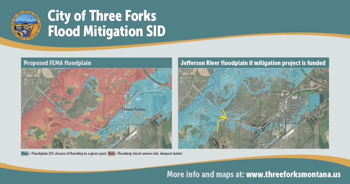
In Three Forks, flooding hasn’t occurred from the Jefferson River since 1948, so it’s just not top of mind. But this is the third flood study done by FEMA for Three Forks. In 2020, the City was informed of FEMA's updated maps and we realized that the flood risk results were going to create big changes for Three Forks. The new FEMA study shows the whole west side of town as being in the floodway, which is the "fastest and highest waters". If a flood of the predicted magnitude happened, it would cost over $60 million in structural damage, clean-up costs, loss of economic activity, loss of public services and critical infrastructure, and a major tax on our emergency services. Essentially, it would destroy Three Forks. There could be significant economic impacts from potential flooding, large costs due to structural damage, clean-up costs, loss of economic activity, loss of public services, loss of critical infrastructure, and emergency services because all are located in the floodplain. The preliminary maps also showed the floodway right in the area our growth policy designated as our main future residential growth area.
Currently, building in the floodplain is doable but there are regulations; but it typically costs a little more and takes a bit longer. Moving half the community into a floodway would add to those restrictions and cause a lot of frustration to our citizens. The City Council knew this was not an option for them and said something must be done to save Three Forks!
Learn more about DNRC's mapping here.
Along with DNRC, Great West Engineering and Headwaters Economics, we started working on a solution to protect Three Forks. As the project progressed, we brought in additional experts from State DES and FEMA Region 8. Long story short, after several public meetings to engage the citizens, we submitted a grant application to FEMA to build (dig) a mitigation channel outside of city limits to divert the potential floodwaters back to the Jefferson River. We used the same 2D model that was created from the DNRC analysis to consider the hydraulics and determine if the proposed channels are large enough, and in the right location, to capture flooding. The proposed conveyance channel would be approximately 8,000 lineal feet. Channel dimensions are anticipated to be 100-feet wide, 5-feet deep, with 3:1 side slopes. The project will include a culvert crossing structure to carry water underneath MT state highway 2 before terminating into a natural side channel of the Jefferson River. The project is estimated to cost just over $6 million.
The first two grant applications were denied, but third time is the charm and the City of Three Forks learned that FEMA selected Three Forks for final review of a Flood Mitigation Assistance (FMA) grant at 75% of the total project cost!
Floodwise Project Recap
We are still actively working behind the scenes on this mitigation project. Our team has submitted the cultural, biological, and historic preservation assessments to FEMA Region 8 to review. Fish, Wildlife & Parks has reviewed and accepted the data. We are at nearly 90% completion of the design phase, and have submitted what is called a Conditional Letter of Map Revision (CLOMR) to FEMA to review how the mitigation channel would affect the maps.
The team met with FEMA Region 8 and State Disaster & Emergency Services in August 2023. With the fall 2025 news of federal grant cuts, we were a little worried. However, FMA grants are still funded so we continue moving forward on this project.
The team spoke at the Montana Floodplain Managers' Conference in Missoula in February 2025, and also presented at the National Conference in New Orleans in May 2025! We are now working on final design, permitting, getting the culverts made and then will go out to bid for construction, hopefully spring 2026.
Funding the other 25%
We then worked on funding the remaining 25% through a Special Improvement District (SID). The SID represents an area in which landowners would be assessed to fund improvements that benefit the district, and the maintenance thereof. Landowners have the opportunity to protest the creation of this district during an upcoming protest period.
Public hearings were held on 9/27/2022 and 10/25/2022 to Create Special Improvement District #34 “Jefferson River Floodplain Mitigation Project & Maintenance”. Zero written protests were received, and the Council approved the creation of this SID at its 10/25/2022 meeting.
We sent the District details to the Treasurer’s office to be on the tax rolls starting in 2023.
The City met with the affected landowners where the proposed channel would be located, and are working on the environmental and historical assessment surveys now, as well as groundwater monitoring.
Complete Memo on Special Improvement District
Once the resolution of intent was approved, a Notice of Intent to create the District was sent to each property owner within the proposed boundaries. This notice was printed and mailed Tuesday, October 4, 2022. Written protests were accepted through October 21, 2022, at 5PM. Protests were required to have been in writing, identify the property owned by the protestor, and be signed by all owners of the property to be qualified.
ZERO PROTESTS WERE RECIEVED!
Click the links below to view exhibits to the resolution.
DNRC Still Progressing Toward Adoption of the Proposed Maps
Although the City learned of the new maps in 2020, the DNRC officially noticed the City of Three Forks that the preliminary maps on August 12, 2025. This starts a clock for FEMA and DNRC to work toward adopting the maps. They anticipate adoption in mid- to late-2027. Learn more here about the Consultation Coordination Office meeting.
Tax BillS
Just a reminder: the Special Improvement District (SID) #34 for the Jefferson River Floodplain Mitigation Channel first appeared on tax bills in November 2023. The Assessment sent to the Gallatin County Treasurer is a maximum of $195.00/year for 20 years, or a total payoff amount of $3,900.00.
Contact Info
Kelly Smith
Floodplain Administrator
406-285-3431
ksmith@threeforksmontana.us
Related Documents
-
Floodplain Mitigation Project
- State DES' "Mitigation Minute" newsletter 9.2025 ( PDF / 3,662 KB )
- Flood Hazard Info Sheet ( PDF / 231 KB )
- Flood Hazard Area Yearly Notice ( PDF / 98 KB )
- Floodwise Project 2023 Recap ( PDF / 1,882 KB )
- Notice of Intent ( PDF / 78 KB )
- Complete Memo on Special Improvement District ( PDF / 4,418 KB )
- List of Property Owners to Receive Notice ( PDF / 137 KB )
- Proposed Maintenance Costs ( PDF / 86 KB )